Feeds:
Posts
Comments

I had a great session at Kletterzentrum Gaswerk (Climbing gym in Schlieren, West of Zurich) today – climbed more 6a, 6a+ than easier stuff for the first time and led half of them. About half way through, I had the insight that when you’re going for a higher grade, or a style of climb you find challenging, it’s better to use shorter routes to push yourself.

This way, you do a short pitch, make it to the top without resting, and feel good – you completed the route! While it’s basically the same as doing a really long route and resting half way up, it feels much better, and gives you more confidence for the next one.

Of course, now I’ve told you this, will it still work…

More Urban Snow Physics

More snow in Zurich and another nice example of the elasticity of snow – temperatures have stayed below freezing throughout.

Couloirs…

I collect couloirs. Unfortunately I’m collecting more in a Google Docs spreadsheet than I am with my skis at the moment. So in an effort to push myself to go out and do more of them, here’s the spreadsheet – a mix from lift served, easy and safe, to long tours in, steep and dangerous.

This list doesn’t contain any from La Grave, one of my favourite spots. I recommend L’Alpe D’Huez Hors Pistes (English and French; also covers La Grave and Les 2 Alpes) if you’re interested.

What’s your favorite? Let me know what you think I’m missing, or if you know a good guide for couloir routes anywhere in Switzerland.

I’m finally going to Flims / Laax next weekend, and while scouting out some off-piste / touring routes, I created an overlay for all the main ski lifts in Flims / Laax.

You can also download the KML for Google Earth.

During the 2008/09 season, I decided I needed new touring skis. My 2004/05 Dynafits were getting a bit old, but the real problem was that they never performed well in powder/soft-snow. So surface area was a major consideration in choosing new ones.

Most manufacturers don’t seem to quote surface area, so I needed to come up with a way of comparing skis of different lengths, widths and side-cuts. Rather than doing it properly, I made a simple model, where a ski is shaped like this:

Ski Surface Model 1and the waist is bang in the middle. This allows you to break the ski down into a long rectangle (A in the diagram below), and four triangles, B1, B2 (of equal area, which together make a rectangle) and C1, C2 (likewise):

Continue Reading »

I use a Garmin eTrex Summit GPS in the mountains. Cheap, robust, waterproof and doesn’t eat batteries as fast as the ones with colour displays and downloadable maps. The downside of this unit is that Garmin don’t make a USB cable, so I bought a third party USB cable from GPS Warehouse (update: the GPS Warehouse e-commerce site has been down since the start of 2010, but you can download pre-Vista Windows drivers here: http://www.belkin.com/uk/support/article/?lid=enu&pid=F5U103vea&aid=7681&scid=255). This comes with drivers for Windows 2000 / XP, but neither GPS Warehouse, nor the manufacturer of the chipset it’s based on provide drivers for Windows Vista.

Fortunately, a number of manufacturers have developed 32-bit Vista drivers, and the one from Belkin for their USB to Serial adapter F5U103vea works on the Windows 7 beta as well. Simply download and follow the instructions on this page:

http://www.belkin.com/uk/support/article/?lid=enu&pid=F5U103vea&aid=8137&scid=0

Here’s the proof:

Garmin eTrex Summit with the GPS Warehouse / Prolific USB to Serial controler on Windows 7 Beta

Garmin eTrex Summit with the GPS Warehouse / Prolific USB to Serial controler on Windows 7 Beta

but if you’re still having problems, the Prolific driver download page points to some other manufacturers who have produced Vista drivers.

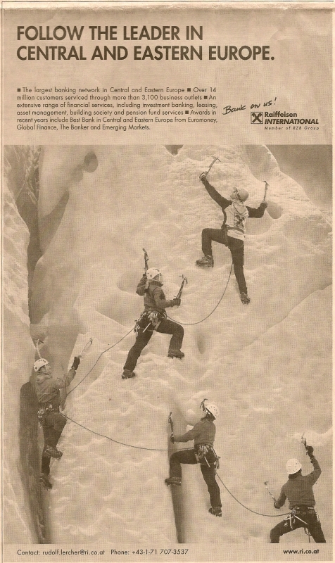
Nope, nothing to do with the Madoff and Medici mess, but an ad that Austrian bank Raiffaissen ran a few times in the FT and other financial press last year to promote their credentials in central and eastern Europe:

What's wrong with this picture?

What's wrong with this picture?

That’s right – five climbers, roped for glacier travel, on vertical terrain with no protection or belay.  So if one falls, they all go. While we’re at it, they’re not even roped properly for a glacier – not enough rope between them (Glacier Travel & Crevasse Rescue by Andrew Selters is a good reference if you want to know more about this topic).

No wonder the financial system’s in such a mess!

Urban snow physics

Avalanche books and courses usually include some cracking photos showing the elasticity of snow when subjected to weak forces: bunching up or sliding gently off a roof without breaking (there’s a good non-urban example here). We found an urban version today at the tram stop near our house in Zurich:

02012009

02012009_002

The roof of the shelter has a very slight slope – perhaps 1:30, and is made of smooth glass. It snowed on New years eve  (2 days ago) just after dark, first raining, then turning to snow as the temperature dropped. It’s been through two melt / freeze cycles since then (between about +/- 2 degrees C). The roof faces more or less south:

Continue Reading »

I’ve been putting my photos on both Picasa and Panoramio for some time now, and more recently on Facebook: Picasa because I use the Picasa 2 photo manager, and it’s dead easy to upload; Panoramio for the geographical presentation (and it’s fun to have your photos in a public Google Earth layer) and Facebook so I can tag people in the photos.

Putting photos in so many places is a bit of a hassle, so when Google announced they were buying Panoramio, I was pleased – hoping for a speedy integration of the two. So far that hasn’t happened, but it’s getting closer – Picasaweb now has support for tags, displays the location of georeferenced photos on a map next to the photo (or for the whole album) and allows you to locate photos using a google map widget very similar to Panoramio’s.

Tags and Locations: Picasaweb on the left, Panoramio on the right


What’s missing? The option to submit your photos to the Google Earth ‘Panoramio’ layer, and a map centric cross-album view of georeferenced photos (like the ‘see this area’ link on the Panoramio screenshot above) and we’ll be there – Google, please hurry up and finish the job.

And while you’re at it, how about adding some GPS tracklog-based georeferencing functionality into Picasa or providing addon support so someone else can do it for you? The current Google Earth-based approach is painful at best, rarely seems to be accurate and doesn’t use GPS tracklogs. Given the Panoramio acquisition and what’s happening now in Picasaweb, this would really make a lot of sense…

One of the difficulty when in Europe is finding outdoor/mountaineering/skiing shops wherever you are. The combined problems of language, a tendency for shops to be smaller (particularly in Italy), and make less use of the Internet, either as a sales or a marketing tool (again, particularly a problem in Italy) make it hard to find what you’re looking for.

The following list may help. I know the Torino area pretty well. Please add a comment if you have any questions.

The best place to find lists of stores are the distributor lists on the web sites of the big clothing / equipment brands. The “La Sportiva” one is pretty good, as almost everyone in Italy stocks their boots:

http://www.lasportiva.com/Italiano/Contatti/Italia/Piemonte.htm

In particular, I’d recommend:

As a rule, everywhere is shut on Sundays and Mondays (at least Monday morning). However, if you’re actually in the mountain valleys, particularly in high season, this may not be the case – but don’t count on it – and in Italy, always ask for a discount!